

Contribution of Eminent Planners
by Kandarp Rajyaguru, Placepoet Architects
The terms Garden City and Neighbourhood are still everyday language in urban planning. Since Ebenezer Howard coined Garden City, it has underpinned city-planning principles in early European towns. Clarence Perry’s neighbourhood concept changed how residential districts are laid out. Baron Haussmann’s rebuilding of Paris made infrastructure the instrument of a modern city. Le Corbusier’s sectoral planning imagined the city as pre-planned, organised, and ordered.
This report traces those ideas, how they have been interpreted over time, and why their essence still matters in contemporary urban work.
Introduction
The aim is to understand the evolution of town-planning theories and practices over the last two centuries. The major breakthrough came in the late nineteenth century, when Howard set out the Garden City — the first clear step towards decentralisation. From there the report looks at neighbourhood planning, how city scale changes those principles, Edwin Lutyens’ plan for New Delhi, and Haussmann’s streets, drainage, and uniform façades.
Keywords: Garden City, pre-planning, town planning, neighbourhood, sectors, nodes, twin city, the City Beautiful, surveying.
Ebenezer Howard — Garden City
The garden cities were the practical form of a simple idea from a shorthand clerk and inventor, Ebenezer Howard. They were a reaction to Britain’s industrial revolution: rapid growth, poor housing, and unhealthy conditions. In the early twentieth century, Letchworth and Welwyn were founded on these principles and are now part of planning history.
Town and country must be married, and out of this joyous union will spring a new hope, a new life, a new civilization.
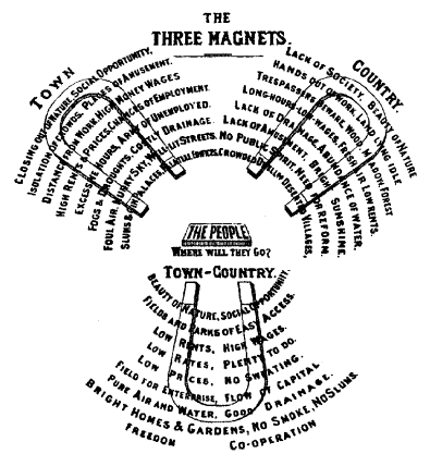
The essential features can be summarised as:
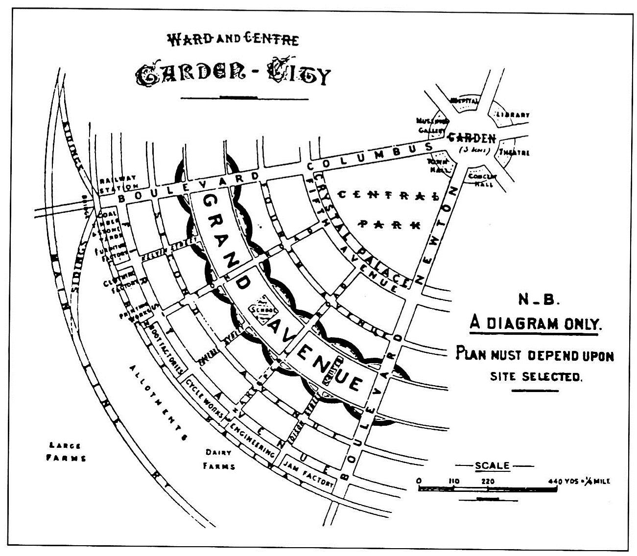
- Organised planned dispersal of industries and people to towns large enough to provide services, a variety of occupations, and a balanced culture.
- A limit of town size (around 30,000) so inhabitants live near work, shops, and the surrounding countryside. New garden cities would be built once the limit was reached.
- Spacious layout: houses with private gardens, space for schools, and parks and parkways.
- A close town–country relationship, with a firm town boundary and a large agricultural belt.
- Pre-planning of the whole town framework, including zoning, roads, densities, and landscape.
- Neighbourhoods as developmental and social entities.
- Unified land ownership under quasi-public or trust control, capturing land value for the community.
- Progressive municipal and co-operative enterprise without abandoning individual freedom in industry and trade.
Patrick Geddes
Sir Patrick Geddes, the Scottish town planner and sociologist, is one of the founders of modern town and regional planning. He argued for survey before planning, or diagnosis before treatment: understand the ills of the town, then prescribe the remedies.
His principles:
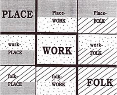
- Town planning primarily meant establishing an organic relationship among folk, work, and place.
- That triad corresponds to organism, function, and environment. The city is a physical utility for collective living and a living organism, governed by definite laws of growth.
- The city is no longer a mere physical structure. It means people, families, communities, and their places to live, work, and play. Human needs come before the physical diagram.
Clarence Perry — the neighbourhood unit
Perry described the neighbourhood unit as the populated area that would require and support an elementary school of 1,000 to 1,200 pupils — a population of about 5,000 to 6,000. At ten families per acre, the unit would occupy about 160 acres, shaped so that no child walked more than a quarter-mile to school. About 10 percent of the area would be recreation. Through traffic would stay on surrounding streets; internal streets would serve residents only. Shopping, churches, a library, and a community centre would sit with the school.
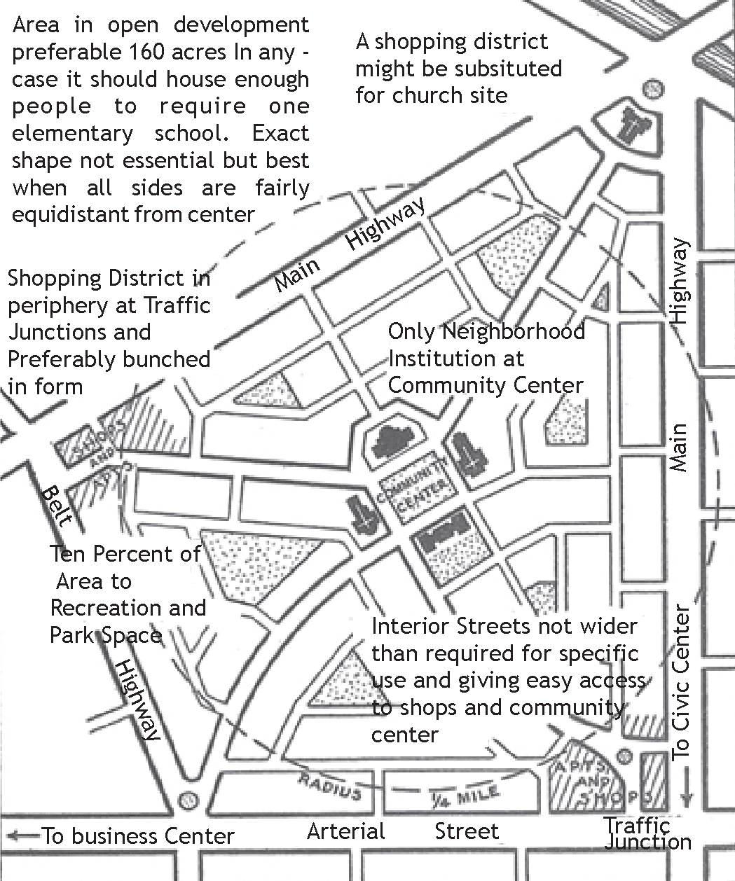
Perry’s six principles:
- Major arterials should not pass through residential neighbourhoods; they should bound them.
- Interior streets should use cul-de-sacs, curves, and light-duty surfacing to keep traffic quiet and low.
- Population should be that required to support the elementary school.
- The school, on a common or green with other local institutions, should be the neighbourhood focal point.
- The radius should be a maximum of one quarter mile.
- Shopping districts should sit at the edge, preferably at major intersections.
George-Eugène Haussmann — modernisation of Paris
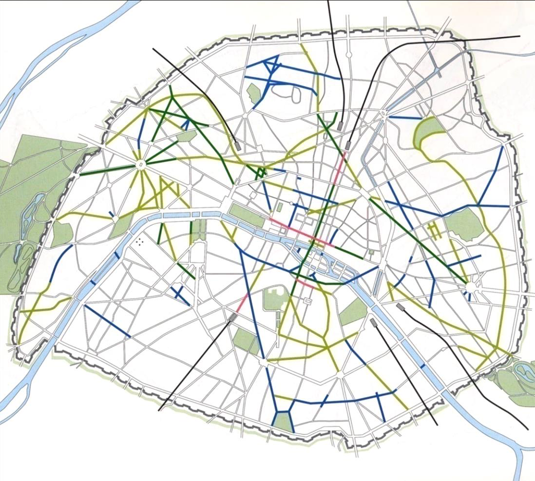
From 1800 to 1850 the population of Paris doubled to over one million. In 1850 most of the city was still a medieval maze of unplanned streets. Open sewers bred disease. In 1851 Napoleon III appointed Haussmann to rebuild the city. His scheme included:
- A reorganised symmetrical road system
- Division of Paris into districts, and expansion
- Wide boulevards
- Gas lighting
- Public building regulations
- Monuments
- Updated façades
- Sewer systems
Many contemporaries mourned old Paris as more intimate and human. The new boulevards seemed too big and empty. From the vantage of our own dehumanised twenty-first-century cities, the Paris of the Second Empire now reads as charming and elegant.
Le Corbusier — the City Beautiful, Chandigarh
Charles-Édouard Jeanneret-Gris, known as Le Corbusier (1887–1965), called for “universal… total city planning” on a twentieth-century scale. His proposed cities could be anywhere: free of context, history, or tradition. “A city should be treated by its planner as a blank piece of paper.” He wanted cities organised, serene, forceful, airy, and ordered.
He believed organically developed cities lead to chaos. His central theme was a strict separation of functions: workplaces, residences, shopping and entertainment, monuments and government. His first dictum: The Plan is a Dictator.
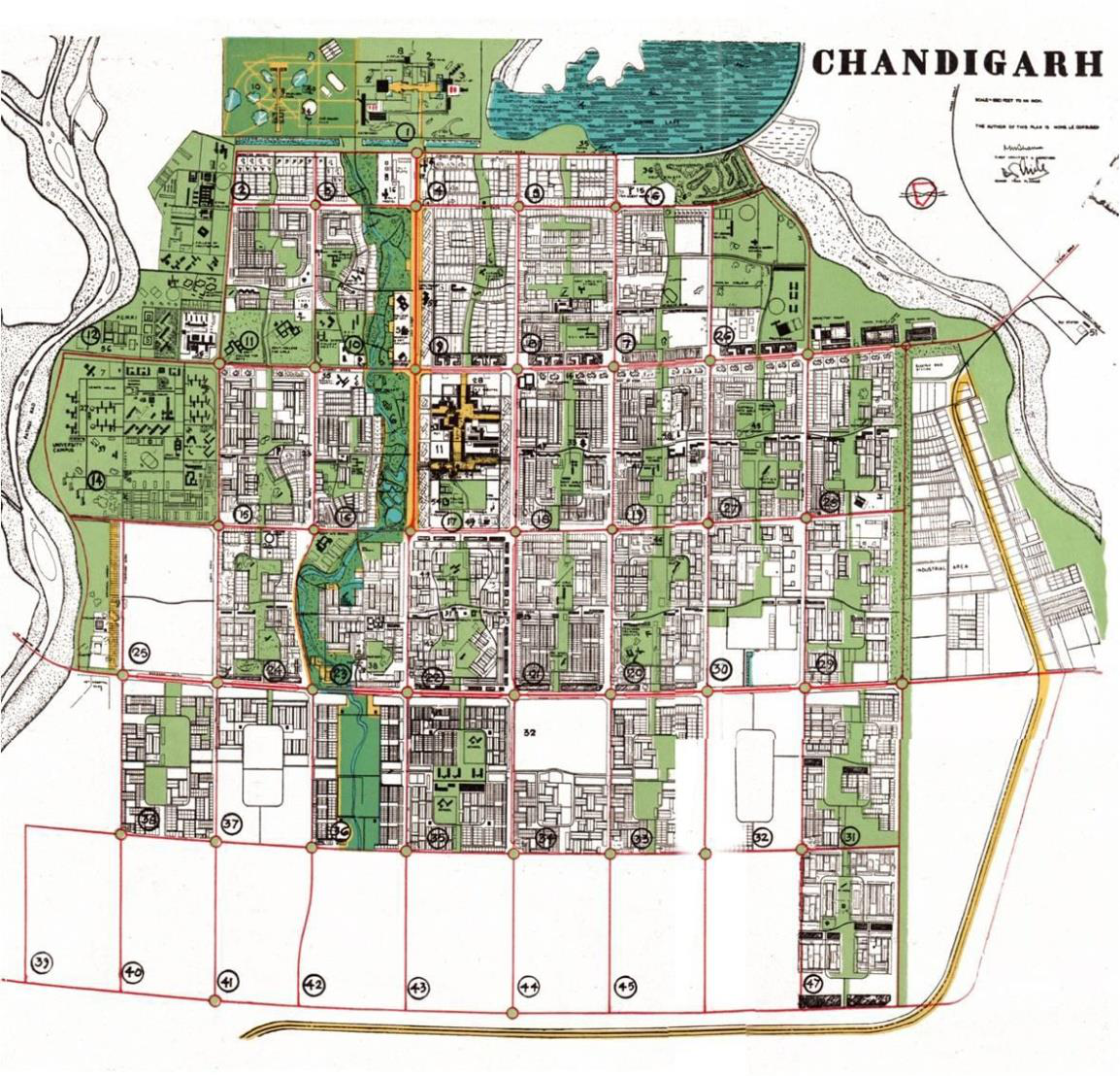
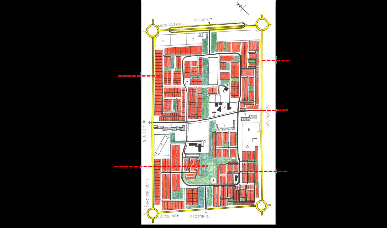
Chandigarh is one of the most significant urban planning experiments of the twentieth century (114 sq km). It follows a grid-iron street layout composed of sectors. The initial design had 30 sectors, each 800 by 1,200 metres, serving 5,000 to 25,000 people. Each sector is a self-sufficient unit with shops, school, health centre, recreation, and worship. The Central Plaza in Sector 17 was designed as a pedestrian’s paradise. Cars enter a sector at only four points — the centre of each side.
| Type of road | Function |
|---|---|
| V-1 | Roads connecting Chandigarh with other cities such as Ambala, Kharar, and Shimla. Dual carriageway, tree plantation, and distinctive central-verge lighting. |
| V-2 | Major avenues with institutional and commercial functions. Identifiable as Marg. |
| V-3 | Corridor streets for fast vehicular traffic. A sector is surrounded by V-2 or V-3 roads. |
| V-4 | Roads bisecting the sector, with shopping along the southern edge. |
| V-5 | Roads meandering through the sector, giving access to inner land. |
| V-6 | Roads off the V-5s leading to houses. |
| V-7 | Pedestrian routes through the green middle of the sector. |
| V-8 | Intended to run parallel with V-7s for bicycles; not properly developed as yet. |
Charles Correa — planning of Navi Mumbai
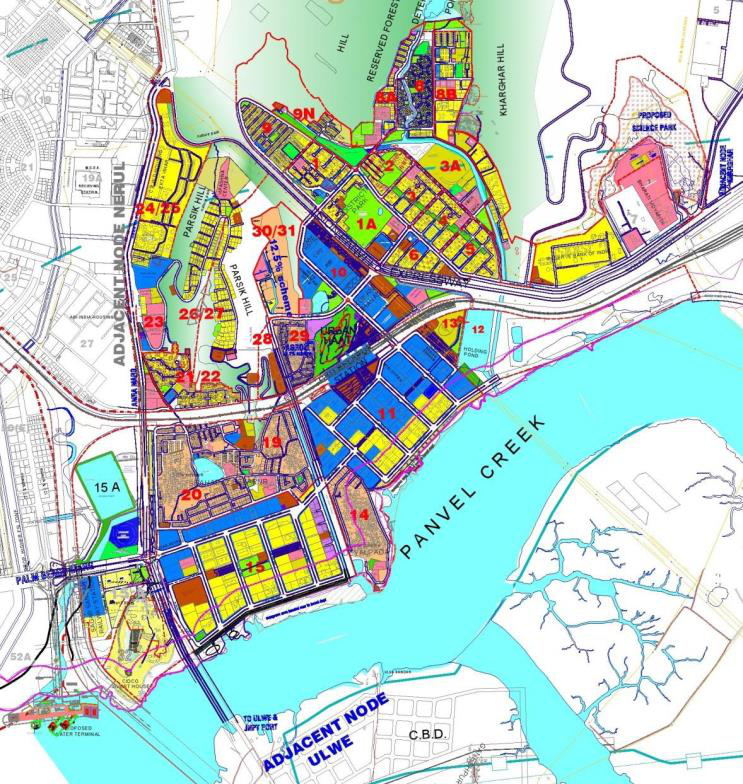
In 1964, Charles Correa, Pravina Mehta, and Shirish Patel presented the government with a proposal for new growth centres across Bombay harbour: Navi Mumbai (344 sq km). The design principles were inspired by Chandigarh’s sectors:
- Decentralisation by self-sufficient townships (nodes)
- Residential neighbourhoods (sectors)
- Single-use zoning rather than traditional mixed use
Navi Mumbai consists of thirteen nodes, each for 100,000 to 200,000 people, divided into neighbourhoods. Nodes contain residential, commercial, infrastructure, and recreational sectors. Almost three times the size of Chandigarh, it adopted single-use zoning to make each unit viable. At a larger scale, nodes share reservoirs and transport. Belapur Node consists of 31 sectors, including Correa’s Belapur housing.
B. V. Doshi — Aranya Housing Society
B. V. Doshi was commissioned by the Indore Development Authority to house EWS families: a target population of 40,000 on an 80-hectare site, with 6,500 plots from 35 to 475 sq m. A central spine of business districts sits with an agglomeration of six self-contained neighbourhoods.
The ideological basis:
- Vitality — development that supports the socio-economic aspirations of the community.
- Imageability — built form that imparts identity and belonging.
- Equity — a balanced community with environmental quality and opportunity for all.
- Efficiency — optimisation of natural, material, and human resources.
- Flexibility — a framework that absorbs growth as a natural process.
- Feasibility — development within the given legal budget.
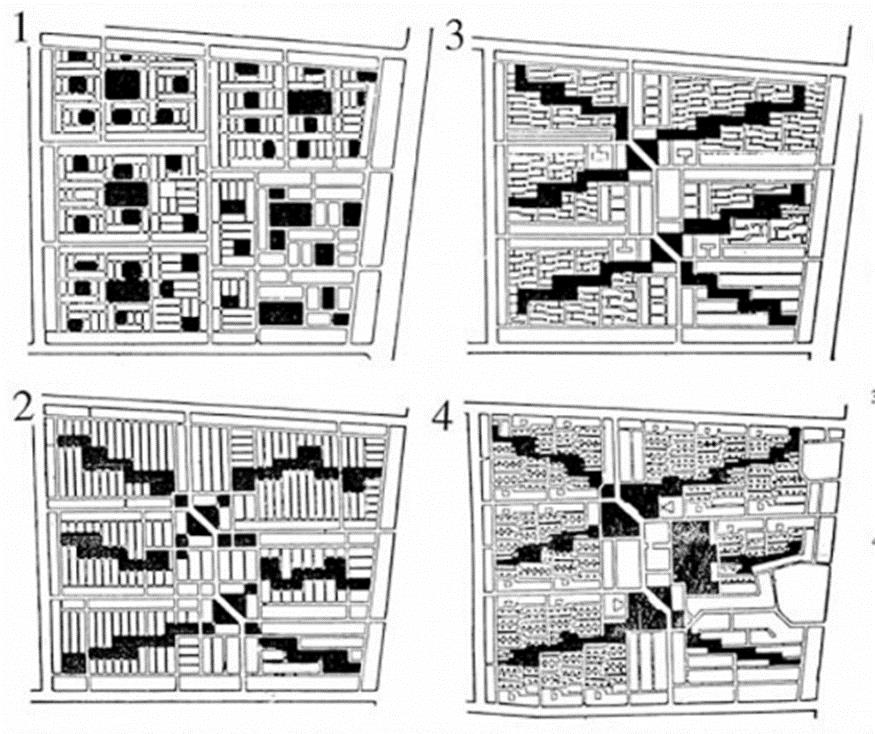
- IDA initial plan.
- Doshi’s initial plan with open spaces and street hierarchy.
- Later stage with rectified orientation for minimum heat gain.
- Final plan with interlinked open spaces and climate-responsive orientation.
Edwin Lutyens — New Delhi
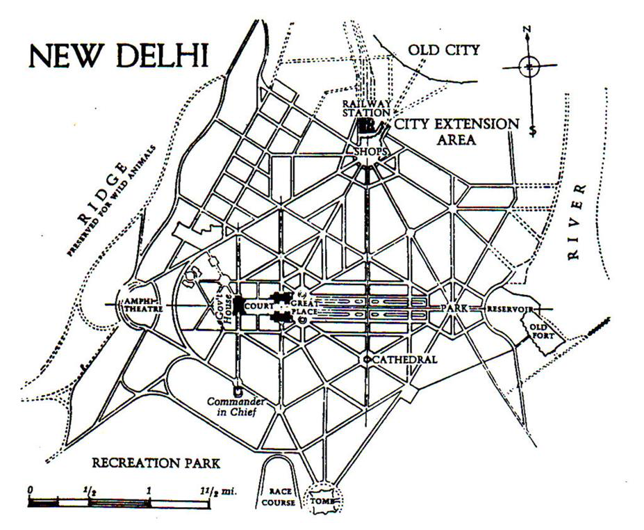
In 1911, King George V laid the foundation stone for New Delhi. Sir Edwin Lutyens was assigned the plan. His first designs used straight lines cutting at right angles, like New York. Viceroy Lord Hardinge warned him about dust storms and insisted on hedges, roundabouts, and trees.
The layout is based on visual corridors and avenues rather than sectors. The road network seeks geometric symmetry through triangles and hexagons (angles of 30 and 60 degrees). The major east–west corridor, Rajpath, connects Rashtrapati Bhavan to India Gate. The north–south corridor, Janpath, radiates from Connaught Place perpendicular to Rajpath. Victorian style mixed with an Indian architectural vocabulary, careful materials, and height restrictions produced a strong urban fabric and a sense of place.
References
- Amit Tungare (2001), Le Corbusier’s principles of city planning and their application in virtual environments.
- Chris Gossop (2006), Garden Cities to New Towns, 42nd ISoCaRP Congress.
- Jacques Guiton, The ideas of Le Corbusier on Architecture and City planning, pp. 93–112.
- Malathi Ananthakrishnan (1998), The Urban Social Pattern of Navi Mumbai, India.
- Meenakshi (2011), Institute of Town Planners, India Journal 8-3, pp. 81–87.
- Michael Adcock, Remaking Urban Space, pp. 25–35.
- Peter Hall and Mark Tewdwr-Jones (2011), Urban and Regional Planning, Routledge, Oxfordshire.